Cottage Surveys
Cottage Surveys
Whether you are a recent buyer of a cottage property and looking to make some changes or a seller that needs to provide an existing survey as a condition of sale we can be your trusted experts to help!
IBW Surveyors and its legacy firm divisions have comprehensive records and expertise surveying much of Ontario’s cottage country. We are familiar with the terrain, the lakes and the municipalities making us a great partner for your project.
Cottage Survey Service Areas:
Haliburton
Minden
Bancroft
Algonquin Highlands
Highlands East
Hastings Highlands
Trent Lakes
Kawartha Lakes
Peterborough
Georgian Bay
The Archipelago
Township of Seguin
Parry Sound
Whitestone
McDougall
Muskoka
Among others!
Cottage Survey Services
You may need a survey to show the location of the cottage on the property, any easements or potential encroachments, and whether the property is owned to the water’s edge. A survey may also reveal if there is fill located on the bed of the Lake, or if there is an original shore road allowance (a strip of land between the property and the water’s edge, owned by a municipality or township). It may also cover how the property is legally accessed. We can provide you with a number of services and will assist you in determining which service best meets your needs.
If the lake is artificially regulated there may be requirements to show specific contours or “high water marks” on a survey. For a site and grading plan zoning setbacks, allowable lot coverage or other related calculations may be required.
We have relationships with local planners and builders that may be able to help with other aspects of your project. Please contact us and we can help answer your questions and give advice on what might be the best type of survey for your needs.
CONTACT IBW SURVEYORS
Cottage Survey Question?
We’re here to help.
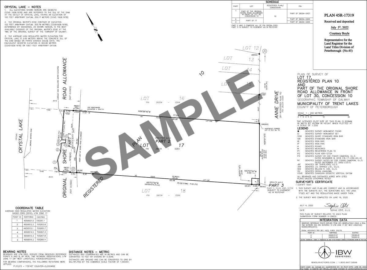
Shore Road Allowance Reference Plan
Are you looking to close an original shore road allowance between your property and the water? Does your cottage property front on an original shore road allowance? What are these shore road allowances and why might you want to close it?
IBW Surveyors has comprehensive records and expertise surveying much of Ontario’s cottage country. We are familiar with the terrain, the lakes and the municipalities making us a great partner for your project.
We can help with preparation of Reference Plans showing the portion of the Shore Road Allowance in front of your property to submit to the municipality as part of the Shore Road Allowance Closing Process.
History of Shore Road Allowances
Many lakes in Ontario Cottage Country have strips of lands located next to them known as Original Shore Road Allowances. These allowances were reserved by the Crown when the first Township surveys were completed in order to allow public access over the strip of land immediately next to the lake (for logging, transportation, camping, portaging, etc.). The Crown has transferred jurisdiction of these Original Shore Road Allowances to the local Municipality or Township.
In the case of flooded or artificially controlled (dammed) lakes, part or all of the Shore Road Allowance may be seasonally or permanently underwater.
Application to a Township/Municipality or the Ministry of Natural Resources?
In the case of Shore Reserves or unorganized territory (no municipality) an Application would be made to the Ministry of Natural Resources to purchase unpatented Crown Land.
🔗 Ministry of Natural Resources: Waterfront boundaries for grants of public (Crown) lands
Shore Road Allowance Application Process
An application for purchasing a shore road allowance is made to the local municipality or township.
As part of the application, or the provisionally approved application you may require:
- A Surveyor’s Real Property Report showing the existing waterfront property and showing any structures that may have been built on the Shore Road Allowance
- A draft Reference Plan showing the dimensions, frontage and area for the part (or all) of the Shore Road Allowance to be purchased.
In most cases the straight line extension of lot lines across the shore road allowance to the water is done, and most municipalities require that neighbors consent to the configuration of the sidelines.
The municipality circulates/provides notice to the public regarding the proposed sale and closure of the shore road allowance and people are given the opportunity to oppose the application.
Once approved by the municipality, a Reference Plan is deposited at the Local Land Registry Office and the municipal council passes a road closing By-law using the Reference Plan as the legal description for the part of the Shore Road Allowance to be closed. The land can then be legally transferred and merged with the upland parcel.
Example Shore Road Allowance Reference Plan – Closing (including adjacent property)
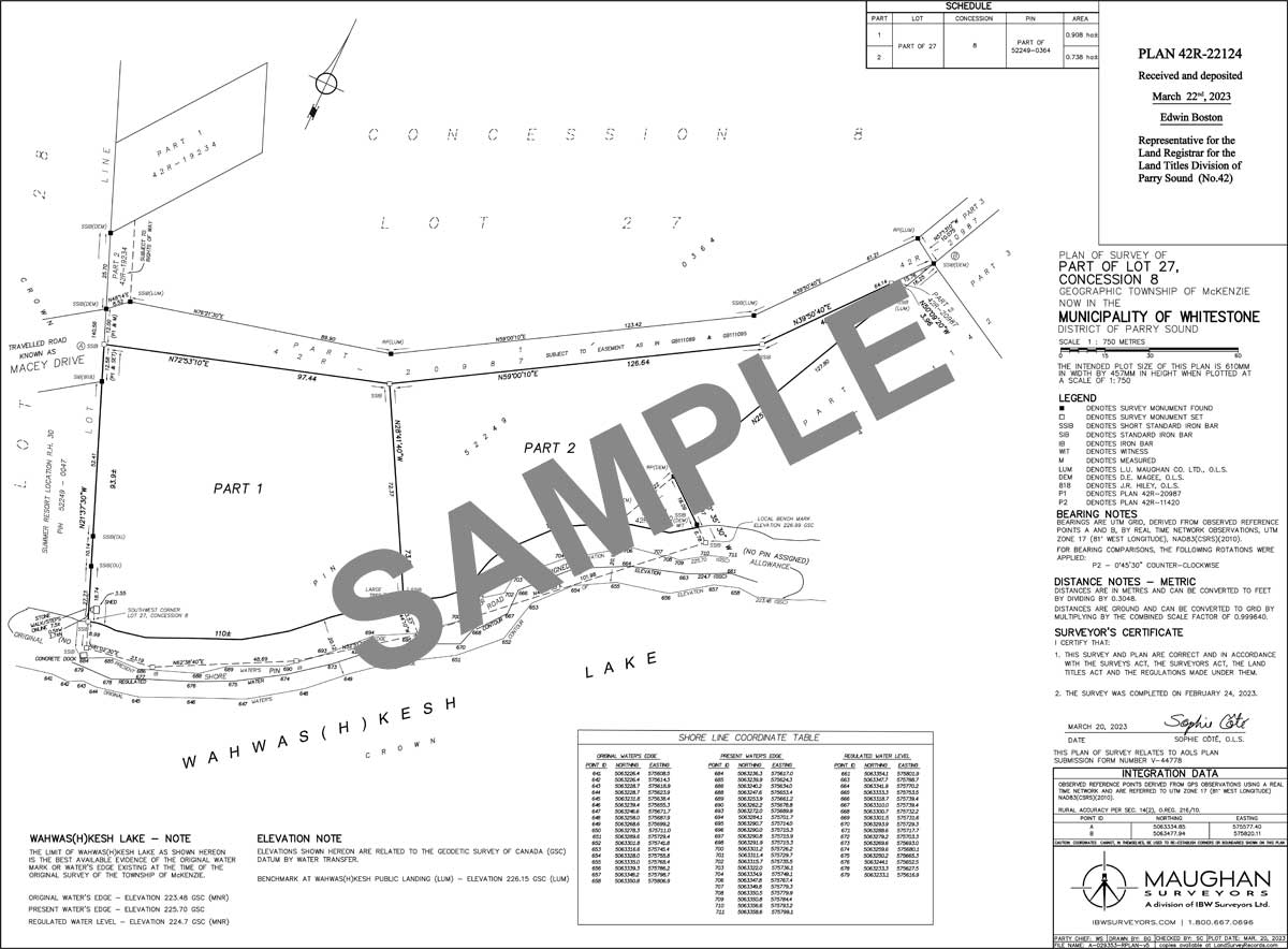
Example Shore Road Allowance Severance Reference Plan – Not Owned
Crown Land Survey
Do you own a cottage and wish to:
- Purchase the Crown Shore Reserve or Crown Shore Road Allowance between your property and the water;
- Purchase filled land placed along your waterfront on the lakebed; or
- Have a two-storey boathouse and must have a survey done in order to purchase the part of the lakebed it sits over.
We can help with that!
87% of the land in Ontario is Crown land. Some Crown land, including parts of shorelines or lake beds, can be purchased through the Ministry of Natural Resources and Forestry (MNRF). The application to purchase Crown Land can be a long process and a Crown Lands Reference Plan will need to be completed by an Ontario Land Surveyor to describe the lands to be purchased.
IBW Surveyors is Ontario’s premier surveyor for cottage properties and can help you navigate through the process. We are familiar with the land, the lakes and various MNRF District Offices, making us a great partner for your Crown Lands Survey project. If you would like to discuss your project with one of our experts, please reach out to us to schedule a free phone consultation.
Crown Lands Process
Step 1: Application Submission
Application for Crown Land submitted to the local district office of the Ministry of Natural Resources to purchase or occupy Crown Land.
If for two-storey boathouse, you may also be required to submit building or site plan drawings as part of the application.
Step 2: Letter from District MNRF Office
Contains a file number and notes that you can arrange for preparation of a Crown Land Survey by an Ontario Land Surveyor.
The Ontario Land Surveyor contacts the specified MNRF contact with the file number and requests Crown Survey Instructions (if applicable)
Step 3: Survey & Plan Preparation
Survey and title records research, field work to retrace existing boundaries and establish new ones according to Crown Survey Instructions and Standards, Calculations, Drafting and Quality control completed by an Ontario Land Surveyor.
Draft plan is provided to the client (and circulated to the district MNRF Office and the Office of the Surveyor General) for approval, then the plan is deposited in the Local Land Registry Office.
Step 4: Crown Patent
The final deposited plan is sent to the Office of the Surveyor General for final review/approval.
They send their package to the District MNRF office that issues an invoice to the purchaser. Once paid District MNRF staff complete documentation that is sent to the Crown Lands Registry. The Crown Lands Registry issues a Crown Patent to the purchaser.
The Crown Lands Plan is used as the legal description in the Crown Patent (transferring the land from the Crown to the purchaser)
Helpful Links and Resources
Read more for insights from lawyers and experts on the importance of conducting surveys.
The Two Story Boathouse
ARTICLE
Waterfront boundaries for grants of public (Crown) lands
ONTARIO MINISTRY OF NATURAL RESOURCES AND FORESTRY
Frequently Asked Questions on Cottage Surveys and Water Boundaries
What equipment is used to survey a water boundary?
Different survey methods and equipment may be used as part of a survey with a water boundary.
- Real Time Network Global Navigation Survey System Equipment (RTN GNSS)
- Total Station
- Water depth measuring pole
- Echosounder mounted on a boat
Depending on how remote your property is, we may ask to use small boat craft available near your property (canoes, rowboats etc.).
How long does a survey for a waterfront property typically take?
Like all surveys, a variety of factors will influence how long a survey that includes a water boundary may take.
- Whether the property has ever been surveyed previously
- If the waterbody fluctuates quite a lot with the seasons (survey work may be seasonally constrained)
- The character of the shoreline (natural, built-up with fill, steep slope, erosion controls placed along the shore, length of shoreline)
- Whether the waterbody is artificially regulated by a dam
- How clear the boundaries are of vegetation/structures
- Topography of the property
How much does a survey for a waterfront property cost?
Like all surveys, a variety of factors will influence how much a survey will cost.
- Whether the property has ever been surveyed previously
- The character of the shoreline (natural, built-up with fill, steep slope, erosion controls placed along the shore, length of shoreline)
- Whether the waterbody is artificially regulated by a dam
- Access to the property
- Size of the property
- How tight the timeline for delivery is
Does my property go up to the water?
Depending on the history of the property, your property may or may not extend to the water’s edge.
Crown Patents sometimes contained reservations reserving a strip of land between the water’s edge and a point inland – sometimes 20.12 metres (66’, 1 chain) wide, sometimes more. An application can typically be made to the Ministry of Natural Resources and Forestry (MNRF) to purchase the portion of Shore Reserve between your property limit and the water’s edge. A Crown Lands Reference Plan would be required to describe the portion of land to be purchased.
Some Original Township Surveys established Shore Road Allowances along rivers or lakes, usually 20.12 metres (66’, 1 chain) wide . Some municipalities offer unused Shore Road allowances for sale, typically there is an application process and a draft Reference Plan is typically required to show structures currently on or near the Shore Road Allowance – municipalities typically want to check existing structures for zoning compliance. The final deposited Reference Plan forms the legal description for the part of the road allowance to be transferred.
Sometimes a dam is installed that changes the water level of the original water body. In cases where the land was patented by the Crown prior to the dam development the original boundary may be flooded (underwater). There may (or may not) be registered flooding rights or flooding easement rights but the flooded land may not have been expropriated. In this case ownership may extend to a flooded limit.
Another circumstance where you may not own to the water’s edge is if fill has been placed or dumped along a shoreline (by artificial, not natural means). In this circumstance the “water boundary” is typically “fixed” to the location it was prior to the fill being placed, sometimes survey records or historical aerial photography is used to aid in determining this.
What should I expect from a survey plan that shows a water boundary?
Depending on the history of the property and the waterbody a survey plan may note different things about the water boundary.
The water boundary will usually show up as a squiggly line with a +/- distance along it. The reason precise distances are usually not shown is because water fluctuates, since it fluctuates, it is not best represented by a precise distance. Sometimes numbers will be shown along the water boundary and there is a table of coordinates shown corresponding to the numbered locations.
There may be notes about the history of the specific waterbody in the Title Block (usually located on the right side of the plan or along the bottom). The Notes section may note the water body is controlled by a dam and also note the Crown patent date of the Lot and Concession the parcel of land is made up of.
If there is a dam on the waterbody an original water edge elevation and a present water level elevation may be noted.
If there is a Shore Road Allowance the Notes may indicate that the water’s edge as shown on the plan is the best available evidence from the time of the Original Township survey and show a space 20.12metres (66’) inland and a thicker line with a +/- distance along it not along the water’s edge.
There may be filled lands indicated along the shoreline if significant fill or structures have been placed along it.
The Notes may indicate relevant Zoning Contours that the local municipality has building restrictions set at.
There may be +/- distance/setbacks shown from the water to any structures located near the shoreline.
Benchmark and vertical datum information are sometimes also noted on survey plans with a water boundary.
It is always a good practice to check with your Local Municipality or Conservation Authority if there are any specifics that need to be represented on your survey plan.
Why is a boundary survey plan necessary?
Depending on what your goals are a boundary survey plan may be useful for different reasons.
- May be required by your local Municipality/Township to apply for a building permit
- Transferring property (Reference Plans can be used to legally describe parcels of land)
- Showing the boundaries of your property with ties to structures on or near boundaries
Talk to a Surveying Expert
Have a Question on Cottage Surveys?
If you have a Vision, we will help you to turn it into reality